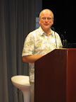
 For our April meeting, Michael Geary gave a rapid fire demo of several different Maps and Mapplets for viewing the results so far from the 2008 primary elections. In the process, he showed us lots of tips and tricks both for server-side scripting of map data and client-side usage of the Google Maps API. He also covered the interaction and performance differences between using Google Maps directly and using Mapplets. He has already written a fairly detailed blog post of his own covering the material he presented that night. The video of his talk is now available online.
 Special thanks go to Googlers Mano Marks and Pamela Fox for allowing us to co-host this final meeting in the current Google GEO Developer Series. Just before Michael took the stage, Pamela provided an introduction to Google Gadgets and how Mapplets fit in that universe as a special variation of Gadgets. We would also like to thank Dick Wall for giving us a brief update on the Android Platform during the networking hour this month. As some of you may recall, Dick was the main presenter discussing Android at our February meeting The video of Dick's Android Update, Pamela's Gadgets Intro, and all the map demos mentioned below is available online here.
We continue to tinker with our GTUG meeting format. We are looking for ways to get more group member involvement in the meetings. We initially tried technical breakout sessions after the main presentation. People typically were most interested in continuing on with Q&A with the main presenter though. Next, we tried technical breakout sessions before the main presentation. We didn't get much traction with that approach either. At this meeting, we invited group members to do brief demos during the networking hour. The demos in order of appearance were:
- Java User Groups International Map: Van Riper did a demo of using basic KML for mapping locations of international organizations like the JUGs Community. Links: Google Docs Presentation, Blog Post, Wiki Page
- Tools for working with the Google Transit Feed Spec: Tom Brown demonstrated two open source utilities. Schedule Viewer is a Python program for viewing the contents of a Google Transit Feed Spec feed on a map. It's a diagnostic program intended for those creating a feed. KMLWriter is an application for plotting a feed's stops in a KML file for viewing in Google Earth
- Putting Video on the Map: Dan Rummel, Justin Cutillo and David Rothschild from Seero gave an entertaining demo that included real-time uploading of video (of them demoing Seero) to a Google Earth application projected on screen for all to see during the demo itself. Fun stuff! Links: Introductory Video, How Seero Uses KML
- Weather Data in Google Earth: Brian Hamlin showed us a humongous amount of weather data in Google Earth. This was interesting stuff, but, be warned that you will need LOTS of RAM to view this data in Google Earth with reasonable performance.
- Google Maps API for Street View: Pamela Fox showed us how easy it is to use Street View functionality with the Google Maps API. She also showed us examples from the Demo Gallery.
- KML Library: Mano Marks showed us libkml. This is Google's library for use with applications that want to parse, generate and operate on KML. It is an implementation of the candidate OGC KML 2.2 standard. It is written in C++ and bindings are available to Java, Python, Ruby, Perl and PHP.
Until we decide to tinker with the meeting format again, there will be opportunities going forward to give your own brief demos at one of our meetings. If you have an application of Google Technology that you would like to briefly demo during the networking hour at a future meeting, please contact us.
No comments:
Post a Comment